Interactive map
Click a marker for the facility record. Search filters the displayed points. “Current” means best-supported operating status in the October 2026 audit; it does not necessarily mean a site was accepting new clients on a particular day.
How the inventory changed
The arithmetic is not a simple “431 minus 21 closures.” The original map contained duplicate/program-level entries, while the current inventory also gained legitimate sites that the earlier map did not contain. A separate 444-site historical master preserves current, closed, and temporary facilities so historical work is not lost.
Downloads and project links
The HTML contains the 410 map points internally, so the map data remain present even if the separate CSV/JSON files are moved. The Leaflet basemap itself requires an internet connection.
What went into this
This layer is the end product of a multi-stage reconciliation rather than a simple address list. Work included combining HSH, DPH, supportive-housing, shelter, behavioral-health and harm-reduction records; reconciling aliases and alternate street addresses; distinguishing programs from physical properties; consolidating multiple programs and floors within the same building; researching relocations and changed uses; adding missing current sites; preserving temporary and closed sites in a separate historical master; checking 2026 operating status; and resolving coordinates for every retained site.
During the historical build, 205 timeline events were reconciled against the earlier master, temporary facilities such as Safe Sleeping Sites and emergency hotels were researched, same-property duplicates were consolidated, and coordinate provenance/confidence was retained where possible. The result is designed for GIS analysis: one mapped point per physical site, while aliases, programs and historical context remain attached to the record.
Methodological caution: proximity on a map does not establish that an incident, overdose, arrest, service call or other event was caused by or connected to a facility. Spatial comparisons should be described as proximity or association unless independent evidence establishes a relationship.
431-to-410 reconciliation graphic
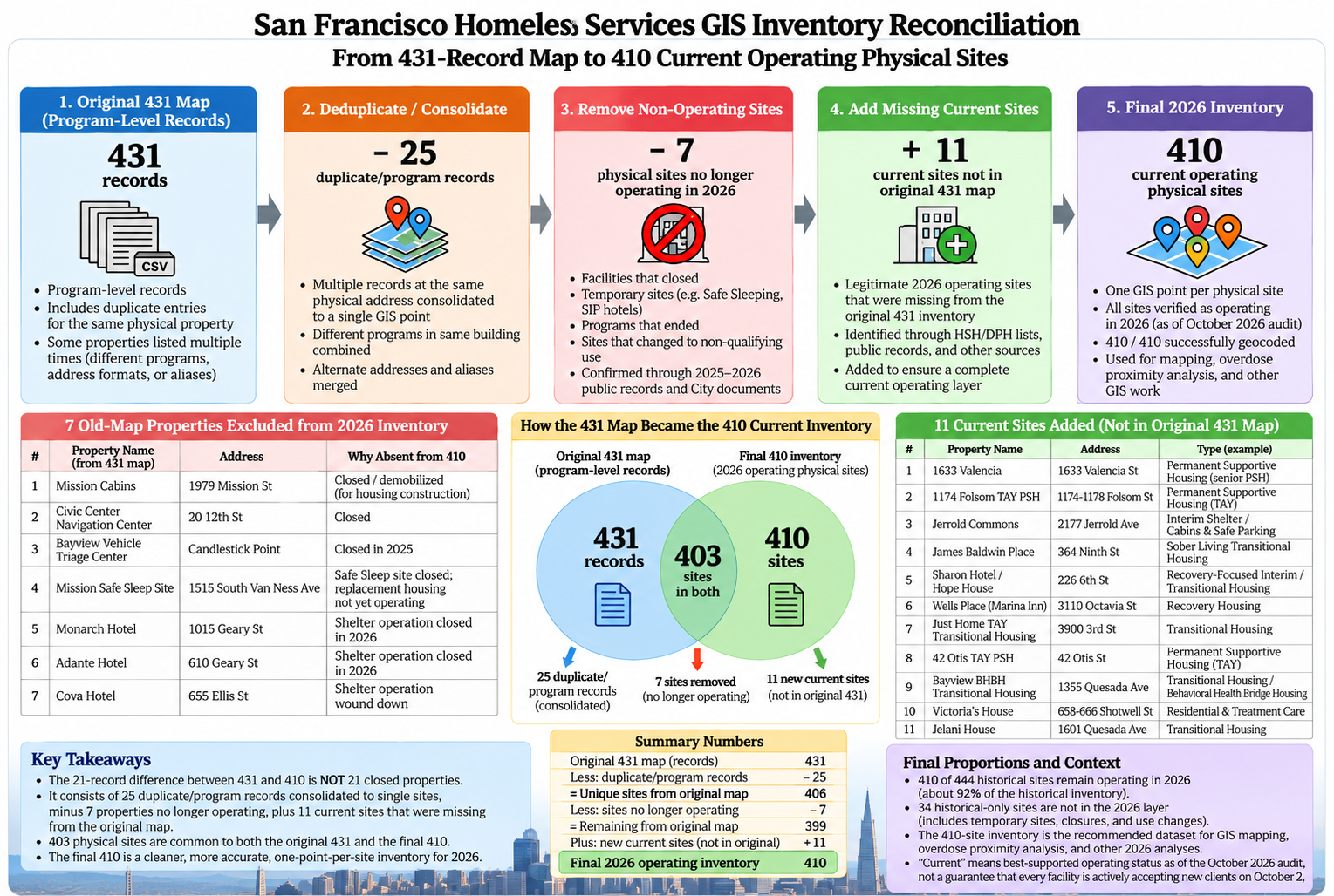
This graphic is explanatory. The final CSV/JSON/GeoJSON and map records are authoritative for individual facility names, addresses and coordinates; some small address text in the generated illustration may not match the final database.
Share this map
Social media card for the 410-site 2026 facility map.